
The history of the European Long Distance Path 1
In 1972, the first European long-distance hiking trails were opened to the public in Constance. The roots of the trail in Germany go back even further.
After the Second World War, there were efforts in some European countries to connect existing national hiking trails internationally and thus also to bring the European peoples and states closer together.
In 1969, these efforts finally led to the foundation of the European Ramblers' Association (ERA) and the plan to connect all European countries with their most famous and interesting historical and natural sights by means of six cross-border long-distance trails (E1 - E6)1.
The main objectives of the ERA were laid down in its statutes: to promote hiking and mountaineering, to protect the environment, to facilitate cross-border hiking by simplifying passport and customs regulations and, above all, to contribute to international understanding2.
This happened at a time when the European states were still separated from each other by secure borders, the "Iron Curtain" divided Europe into East and West and a real European unity was still a long way off.
Referring to this time and its political circumstances, Jan Havelka (former President of the ERAV) explains in a speech from 2005:
„[…] That is why the idea of establishing long-distance footpaths for the rapprochement of European peoples and states could seem to be pure utopia.
In some Central and Western European states, however, the paths began to be marked and a map with planned routes through the whole of Europe was created. Even the map itself aroused enthusiasm in some people and fear in others. That alone indicated the strength of the idea."
A Paths Commission was set up, whose task was to network the existing national paths and to coordinate the work of the nationally or locally responsible hiking associations.
On 2 July 1972 - only three years after the foundation of the ERA - the first European long-distance hiking trails were opened to the public in Constance, where the E1 and E5 cross. A bronze plaque still commemorates this event.
When it was handed over, the E1 was still far from being "finished" and continuously hikable. Some sections, especially in Scandinavia and Italy, only existed on paper or still had to be worked out.
However, since the handover, the route has been further concretised and sections of the route have been continuously added and connected. On 4 June 2013, for example, the Norwegian DNT completed the route in a northerly direction to the North Cape3. The majority of the E1 is now hikable, even if only parts of it are marked with a special sign.
For a few years, the northern Italian city of Genoa was the southern terminus of the E1, but it is now possible to continue the route southwards over the Appenine mountain range. The continuous route currently ends south in Fortino on the border of Campania and Basilicata.
On 26.04.2016, a first section was opened in Sicily between the Monti Nebrodi and Nicolosi.4 The missing sections in Basilicata, Calabria and Sicily are currently being worked on. In the south, the final E1 is to end at Capo Passero.
In Schleswig-Holstein, a western variant has been added to the E1. This is also marked with the St. Andrew's cross throughout.
The roots of the E1 in Germany
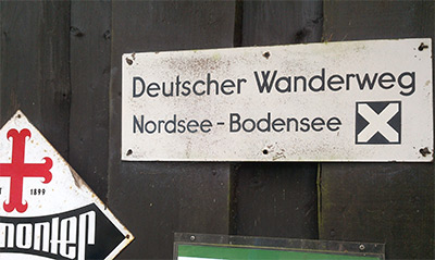
In Germany, the route of the E1 was largely based on the route of an existing long-distance hiking trail. At the German Hiking Day in Königstein/Elbe in 1929, the decision was made to establish several large long-distance hiking trails through Germany. These included the "German Hiking Trail North Sea - Lake Constance" in a north-south direction and the "Saar - Silesia Hiking Trail" in a west-east direction. These trails were realised and marked in the 1930s.
The North Sea - Lake Constance Trail largely corresponds to today's E1 on German territory, and was also marked with the St. Andrew's Cross, which is still valid today. However, the designation "North Sea" in the name is somewhat misleading, as the trail ended in Hamburg in the north, a good 100 kilometres from the coast.
In order to be able to integrate the former "North Sea - Lake Constance - Path" into the planned E1, a connection to the Danish border had to be created in a northerly direction. This connection was realised in time for the handover in 1972 by the North German Hiking Association.
Unless otherwise stated, the information on the history and development of the E1 and the EWV comes from conversations with Frank Schlinzig in autumn 2015 or documents provided by him. Frank Schlinzig was, among other things, the chairman of the European Ramblers' Association's trail commission for ten years as well as the chief trail warden of the German Ramblers' Association. My personal thanks go to him for his friendly and extensive support during the research.
Sven Lewerentz, 07.02.2016
Source reference
1: From a speech by Jan Havelka at the German Hiking Day 2005 in Thuringia.
2: „Auf Europas großen Wegen“ by Robert Wurst, 1996, ISBN 3-222-12346-2
3: DNT - https://www.dnt.no/e1/
4: FIE Sicilia - http://www.fiesicilia.it/ (Link defekt)

"Geschichte des E1" von Fernwandern in Europa ist lizenziert unter einer Creative Commons Namensnennung - Weitergabe unter gleichen Bedingungen 4.0 International Lizenz.